The Whitsundays
When exploring the Whitsundays on a bareboat charter, using public moorings is a safe and environmentally responsible way to enjoy key anchorages around the islands. Managed by the Great Barrier Reef Marine Park Authority (GBRMPA), these moorings are designed to protect fragile coral reefs from anchor damage and are free for public use on a short-term basis. You’ll find them in many of the most scenic and sheltered locations, including popular snorkelling and diving spots such as Blue Pearl Bay, Butterfly Bay, Luncheon Bay, and Stonehaven.
As part of your pre-departure briefing, we’ll explain and show you how to safely use public moorings, share tips on timing your arrival to secure a spot, and provide charts showing their exact locations.
Mooring and Etiquette Tips
Time Limits
Public moorings are generally limited to 2 hours during the day and may be available overnight depending on the location and conditions.
First Come, First Served
Moorings cannot be reserved, so plan to arrive early, especially in peak season.
Check Load Ratings
Each mooring has a colour-coded tag indicating the maximum vessel size and conditions under which it can be used.
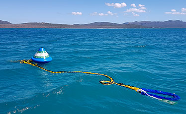
Public moorings are available at popular locations throughout the region. These blue cone-shaped buoys have a colour-coded band indicating class (vessel length), time limits and wind strength limits.
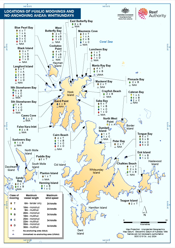
Mooring Table
| COLOUR CODE | CLASS | MAX. VESSEL LENGTH | MAX. WIND SPEED | |
| BROWN | T | 6m (tender only) | 24kts | |
| YELLOW | A | 10m (monohull) | 9m (multihull) | 24kts |
| GREEN | B | 20m (monohull) | 18m (multihull) | 34kts |
| BLUE | C | 25m (monohull) | 22m (multihull) | 34kts |
| RED | D | 35m (monohull) | 30m (multihull) | 34kts |
Public Moorings Map
The Great Barrier Reef is a nautical paradise. As you navigate the waters of the Whitsundays, please keep your ripple effect small by practising careful anchoring and mooring.
Doing so helps ensure the region remains enjoyable for everyone while protecting its delicate marine habitats, like coral reefs.
This map provides vital information on the locations of public moorings to safeguard this remarkable natural wonder for future generations.
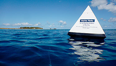
Reef Protection Markers
The Great Barrier Reef contains many well-developed fringing reefs that are particularly vulnerable to anchor damage. To protect these highly diverse coral communities, there are reef protection areas where anchoring is not allowed. Most no-anchoring areas are marked by reef protection markers.
No-anchoring areas are easily identified by their white, pyramid-shaped buoys with a blue label (joined with an imaginary line). Anchoring on the shore side of the imaginary line is not permitted.
How to Pick up a Mooring
Thinking about it?
Enquire today & get the conversation started!